Where FT2 Physically Touches CSC – Drone View, Map Walk-Through & Investment Analysis
In this detailed on-ground update, we break down one of the most important developments in the Islamabad motorway corridor: Faisal Town Phase 2 and Capital Smart City physically touching each other.
This is not just a marketing statement — it is a geographical reality that has major implications for:
- Access routes
- Future commute times
- Development synergy
- Commercial viability
- Long-term real estate value
Using fresh drone observations and simplified map explanations, we analyze what this boundary means for buyers, builders, and investors in 2025.
For verified maps, official price sheets, GPS-confirmed site visits and professional advisory:
GAINS REAL ESTATE AND MARKETING PVT LTD
📞 Call: 03331003535
📞 Phone / WhatsApp: 03355592930
🌐 https://malikjunaid.com
Why This Boundary Matters
When two major housing projects physically meet, three things usually happen:
- Shared Access Advantages
- Price Benchmark Influence
- Development Pressure & Competition
Faisal Town Phase 2 (FT2) and Capital Smart City (CSC) are both positioned near:
- M2 Motorway
- Thalian Interchange
- Islamabad International Airport
- Rawalpindi Ring Road alignment
Official project portals:
🌐 https://www.faisaltownphase2.pk
🌐 https://capitalsmartcity.com.pk
The fact that they physically touch along a defined corridor creates a new investment dynamic.
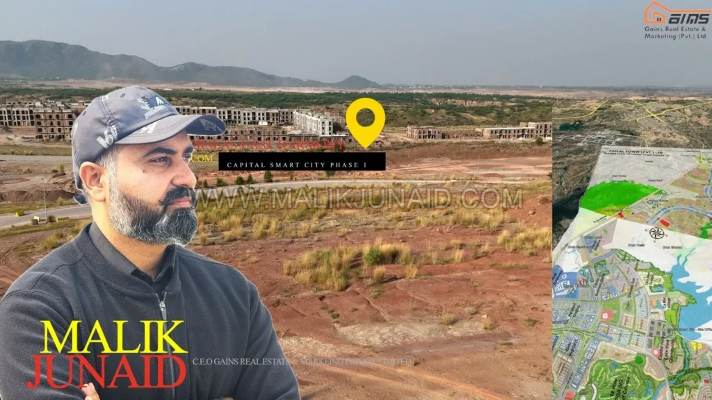
Boundary Touch Point – Exact Corridor Explained
Drone flyovers confirm a visible edge where:
- FT2 land meets CSC boundary lines
- Road networks approach from both sides
- Leveling and infrastructure works are visible
This is not theoretical adjacency — it is a physical meeting of land parcels.
From an aerial perspective:
- Earthworks and grading show aligned development progression
- Road planning grids appear compatible in orientation
- No large undeveloped buffer separates them
This proximity changes the way investors must analyze both societies.
What Happens When Two Mega Projects Touch?
Historically, when two large housing projects share a boundary:
✔ Traffic flow increases
✔ Commercial opportunity multiplies
✔ Access options expand
✔ Competitive pricing begins
✔ One project benefits from the branding of the other
Capital Smart City is marketed as Pakistan’s first smart city, while Faisal Town Phase 2 carries developer brand recognition and aggressive pricing.
When they meet physically, market psychology shifts.
Access & Connectivity – Real Implications
One of the most important impacts of the shared boundary is connectivity spillover.
Motorway M2 Access
Both FT2 and CSC benefit from:
- Direct access to M2
- Reduced dependence on inner-city traffic
- Quick airport approach
Commute estimates (traffic dependent):
- To Islamabad Airport: 8–15 minutes
- To Zero Point: 25–35 minutes
Thalian Interchange Influence
The Thalian corridor plays a crucial role in linking:
- CSC internal roads
- FT2 approach roads
Investors should physically test access routes rather than relying on brochure claims.
Service Roads & Boulevards – What to Check Before Booking
Before booking near the boundary area, check:
✔ Is there a connecting road planned or constructed?
✔ Is access direct or via secondary roads?
✔ Is the boundary near a commercial belt?
✔ Are there future road widening plans?
✔ What is the road width near your plot?
These micro-factors determine resale strength.
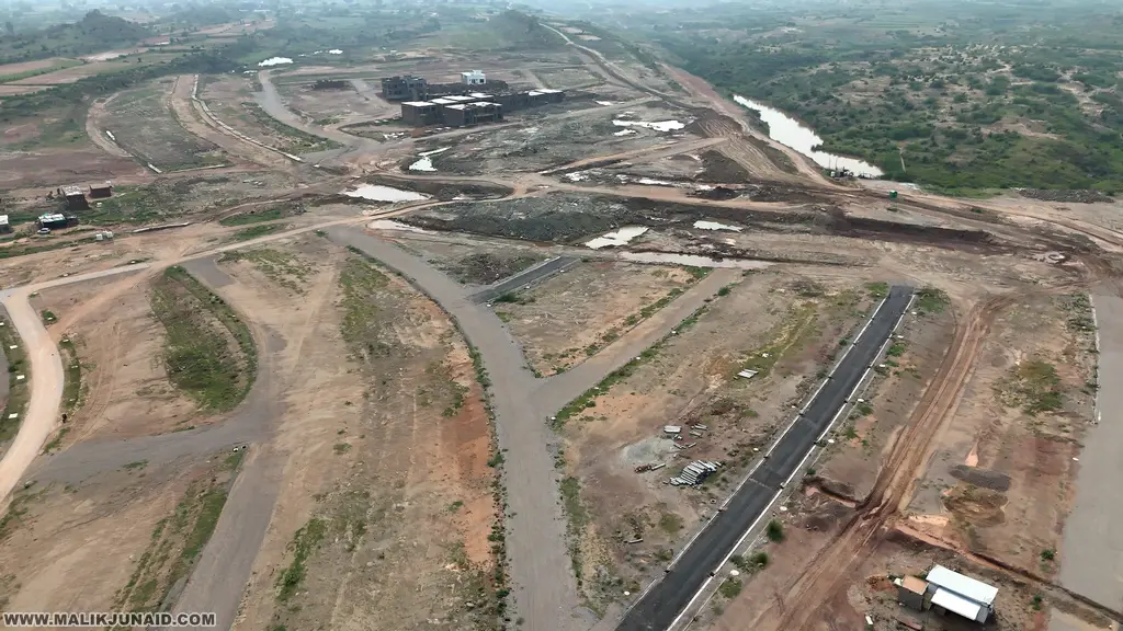
Latest Development View – Drone Insights 2025
Recent drone coverage shows:
- Road leveling activity
- Infrastructure trenching
- Plot demarcation lines
- Heavy machinery presence
- Gradual utility installation
In boundary zones, development speed is often accelerated to:
- Showcase progress
- Strengthen competitive positioning
- Attract cross-project buyers
Map Explained – Simple Sector Alignment
When analyzing the FT2 & CSC boundary on map:
Step 1 – Identify Edge Blocks
Look for blocks closest to outer boundary lines.
Step 2 – Check Commercial Alignment
Commercial belts near shared boundaries often become high-traffic zones.
Step 3 – Understand Boulevard Direction
If a main boulevard runs toward the boundary, that edge becomes high-value.
Step 4 – Compare Plot Sizes
Premium categories (10 Marla, 1 Kanal) near boundaries may benefit from proximity premium.
For verified boundary maps and orientation analysis:
📞 03355592930
🌐 https://malikjunaid.com
Investment Lens – Who Should Buy Where?
For Short-Term Investors
FT2 may offer earlier liquidity cycles.
For Long-Term Strategic Investors
CSC’s master planning depth and smart infrastructure model may create higher long-term premium.
For Builders
Choose plots:
- Close to main roads
- With easy heavy vehicle access
- Near completed development
Commercial Potential at the Shared Edge
Boundary-touching areas often become:
- Retail connectors
- Small business hubs
- High foot-traffic corridors
Why?
Because residents from both sides gravitate toward:
- Nearest commercial activity
- Shared entry routes
- Accessible service zones
Commercial investors should study boundary belts carefully.
Corner vs Boulevard Premium – Explained
Corner Plots
Advantages:
- Dual road access
- Higher visibility
- Easier architectural design
Disadvantages:
- Higher cost
- Slightly larger exposure area
Boulevard-Facing Plots
Advantages:
- Prestige address
- Higher resale demand
- Commercial conversion potential (where approved)
Near boundary zones, boulevard alignment becomes critical.
Commute Time Impact
Shared boundary can:
- Shorten access routes
- Reduce congestion
- Create alternate exit options
However, always test:
✔ Morning peak drive
✔ Evening peak drive
✔ Weekend flow
Never assume commute advantage without verification.
Development Competition – Positive or Negative?
Competition between neighboring projects can:
✔ Accelerate infrastructure
✔ Increase marketing intensity
✔ Raise development standards
✔ Improve amenities
But it can also:
⚠ Create price pressure
⚠ Increase promotional noise
⚠ Lead to buyer confusion
Professional advisory helps navigate this.
Due Diligence Checklist (Very Important)
Before payment:
✔ Verify latest NOC status
✔ Confirm map revision version
✔ Check transfer procedure
✔ Confirm development charges
✔ Inspect on-ground demarcation
✔ Review official receipts
Regulations and maps change frequently. Always verify with relevant authorities.
Strategic Comparison – FT2 vs CSC at the Boundary
| Factor | Faisal Town Phase 2 | Capital Smart City |
|---|---|---|
| Development Model | Rapid marketing model | Smart master-planned model |
| Branding | Developer-driven | Smart city positioning |
| Map Spread | Structured | Larger, tech-integrated |
| Long-Term Vision | Expansion-oriented | Smart infrastructure focus |
Both benefit from physical adjacency.
Risk Considerations
While boundary proximity increases opportunity, consider:
- Regulatory clarity
- Development pace consistency
- Infrastructure completion timelines
- Official documentation updates
Always prioritize verified data.
Why Choose Gains Real Estate & Marketing Pvt Ltd?
We provide:
✔ Boundary-verified maps
✔ GPS plot confirmation
✔ Drone-based visual documentation
✔ Updated price sheets
✔ Development status tracking
✔ Transfer procedure assistance
📞 Call 03331003535
📞 WhatsApp 03355592930
🌐 https://malikjunaid.com
Final Conclusion – What This Means for 2025 Buyers
The fact that Faisal Town Phase 2 and Capital Smart City physically touch each other is not just a geographic detail — it is a strategic investment factor.
It influences:
- Accessibility
- Commercial logic
- Future commute convenience
- Value benchmarking
- Competitive development standards
For serious investors, boundary zones are often high-opportunity pockets — but only if chosen carefully with proper due diligence.